WP1: Repeated hydro acoustic munition and sediment mapping, visual observation and sediment sampling
GEOMAR Helmholtz Center for Ocean Research Kiel
Using historic research and past field measurements, the approximate location of buried munitions in the North and Baltic Sea is quite well documented. However, the exact position on the seafloor and the extent of relocation or burial processes caused by currents and storm events is mostly unknown. Thus, reliable estimates on location and transport of munitions with respect to burial depth and exact position are not possible at the moment.
Aims and responsibilities
The aim of WP1 is to determine the exact location of buried weapons and sediment cover using repeated, ship-based hydro acoustic and visual measurements. By systematically comparing these measurements, a possible transport of the buried weapons can be identified and reconstructed. In addition, local and regional sediment relocation processes, which might lead to burial or exposure of weapons, can also be detected.
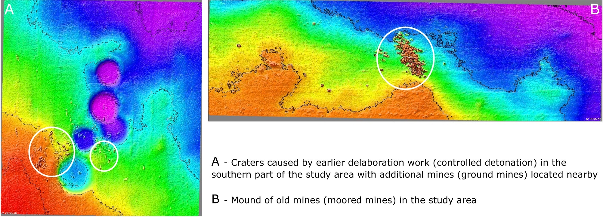
Additional hydro acoustic sediment mapping, so-called sub-bottom measurements, is used to determine the general geological condition and sediment dynamics of the study area. Based on these measurements, the small-scale structural geology of the study area and thus the morphodynamic sediment processes (e.g. relocation, ripples) and also buried weapons can be identified. The extensive hydro acoustic mapping with ship-based (multibeam) echosounder systems and sub-bottom profilers is the base of a non-invasive inventory of weapons at submarine disposal sites. This is also part of the partner project RoBEMM and here of specific interest to choose a testing area to conduct two full-scale tests as well as to develope an offshore validation method.
Furthermore, extensive mapping with modern echosounder systems can also be used to identify biological habitats (in accordance with the geological setting) and is therefore closely linked to the tasks of WP4 and also WP2, in combination with visual observations and ground truthing by sediment sampling.
- Repeated, ship-based echosounder measurements of the study area for bathymetric mapping and exact location of weapons and munition on the seabed
- Identification of sediment and object relocation processes and their quantification using statistical methods (e.g. cross correlation)
- Geological characterization of the dumping sites by combining of backscatter, bathymetric and sub-bottom data together with visual observations and sediment sampling
- Standardized habitat mapping using “supervised” and “unsupervised” classification
- Achieve the maximum precision for locating the weapons and munition on the seabed by using Real-Time kinetics (RTK) and/or geodetic post-processing positioning services (GPPS-SAPOS)
- Precise 3D-visualization of the identified weapons using photogrammetric methods (depending on visibility)