
WP2: Detecting and modelling of the coastal currents and water transport
IOW Lebniz Institute for Baltic Sea Research Warnemünde
To quantify a possible dispersal of contaminants in seawater and therefore the environmental impact, detailed knowledge of the current conditions and the sediment dynamic in the study area is essential. These factors also need to be considered in their temporal variability on a daily (tides, storm events), weekly (lows, inflow events) and annual (seasonality) basis. There are existing current models for both the North and the Baltic Sea that can be applied on larger scales.
Detailed studies were carried out along the German Baltic coast, for example to assess the ecological consequences of cold water influx into the Greifswald bodden or the environmental impact of a planned permanent Fehmarn Belt crossing. During the BMBF-funded project PACE, the hydro dynamics and suspended matter dynamics in the tidal flats of the North Sea were successfully investigated. Over the last couple of years a modelling system for the German coastal waters was developed at the IOW, which allows realistic and high-resolution simulations on a local scale (e.g. during the large Baltic Sea inflow event in December 2014). This modelling system is currently being expanded within the framework of the BMBF-funded project MOSSCO by implementing additional components like sediment and swell modules.
However, the possible dispersal of contaminants (in this case from old weapons and munition or their by-products) is still a challenge for the model. One aspect of WP3 is to investigate how the contaminants are being transported: 1) in solution or 2) through accumulation at suspended matter (sand, silt, organic particles). In the first case, the transport of the contaminants is strongly influenced by the residual transport and thus an estuarine circulation (distal transport in surface water masses and coast-directed transport in near-bottom currents). Especially these near-bottom currents are a challenge during the delaboration of the weapons, since possible contaminants could be released and transported to the nearby beaches. Although contaminants have a high transport range in solution, the absolute concentration is diluted over time. In the second case, the interaction of currents and waves is very important, since only the wave-induced soil shear stress transports sand and silt particles from the sediment into the water column.
There are different re-distribution patterns depending on the suspended matter fraction. Larger suspended matter fractions (e.g. sand) sink faster and thus are only re-distributed locally. Higher transport ranges can be observed If the contaminants are adsorbed to silt particles, since these particles can remain inside the water column for several days. In addition, the concentration of the contaminants shows only little dilution over time if adsorbed onto suspended matter and transported through the water column. Therefore, quantifying the transport of chemical contaminants requires a deep understanding of suspended matter transport and dynamics.

The figure (see above) shows an example of results of the physical model GETM and a passive tracer continuously released in the bottom water in the restricted area “Kolberger Heide” (red dotted line) and simulating the release of compounds typically found in explosives. The compounds can be transported eastwards along the coast (February 2006) or may penetrate westwards into the Kiel Fjord (September 2006). The arrows indicate the average wind direction at the two periods.
Aims and responsibilities
To investigate the dissemination of the contaminants a combination of both modelling and field measurements is used. One long-term (3-6 months) profiling current sensor is deployed in each study area and the physical properties of the water column are measured (temperature, salinity, turbidity). The data collected from these measurements will be implemented into high-resolution current models (Purikani et al., 2015; Gräwe et al., 2013) of the study area to simulate the current conditions and therefore the dissemination of chemical contaminants and their potential impact on different habitats.
Based on the maps generated from WP1, the morphological changes are identified and monitored, which can then be used to validate the morphological reconstruction produced by the model and in addition to evaluate the predictive value of the results. Furthermore, the model is used to assist in the planning of sampling stations (water and sediment) within WP3 and WP4 to investigate the dissemination of chemical contaminants during the disarming of the weapons.
The model is also used to predict the consequences of tidal influences on the dissemination of the contaminants, which will be important during the delaboration process especially in the North Sea. Here, the release of particles from a source point (in UDEMM the drift of contaminants) can be simulated using a 3D particle tracking tool that was advanced at the IOW (Gräwe and Wolff, 2010) and also enables forward and backward simulations.
Especially the backward simulations can be used to gain new insights into the transport of contaminants through the water column and can also help to identify the source of the contamination. Two forward model calculations for a period of 1 and 2 years respectively are planned prior to the delaboiration to facilitate an optimized sampling strategy within WP3 and WP4.
Results Oceanographic Field Measurements
For the munitions dumping side Kolberger Heide, which serves as a test region in this project, currents, salinity, temperature and turbidity has been monitored by ADCP and SeaCat measurements between 2017 and 2018 to later on validate the modeled hydrodynamics. The currents close to the bottom are slower than at the surface (0.04m/s compared to about 0,3m/s). The direction of the current is mainly westnorthwest in the surface layer and varies between northwest and southeast in the bottom layer. The turbidity is on average low. The salinity and temperature points at minor small-scale inflow events.
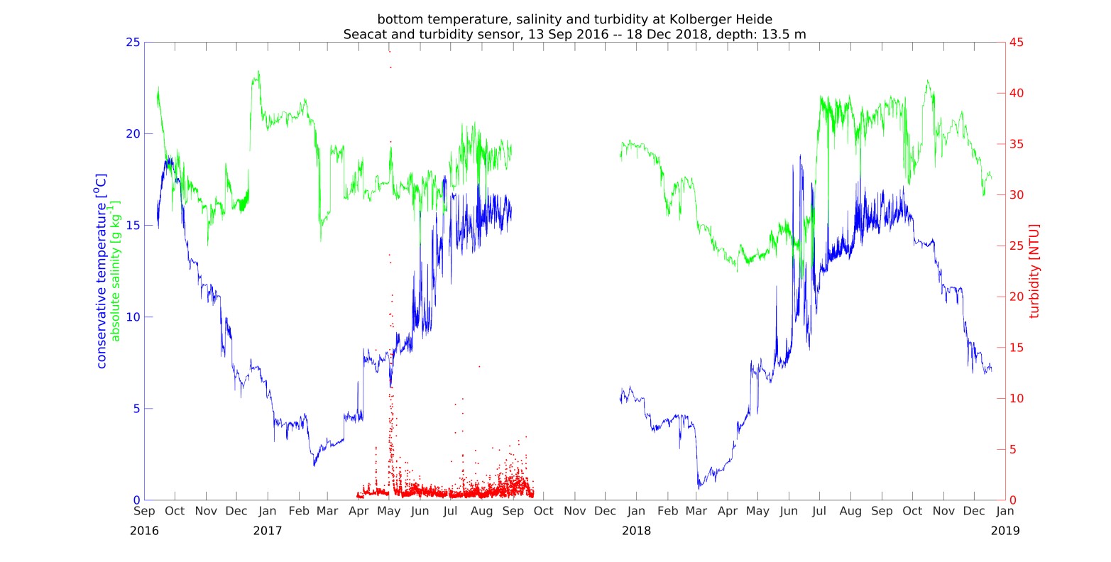
Time series of temperature (blue), salinity (green) and turbidity (red) close to the bottom.
The comparison of the measured temperature with the modeled temperature in the bottom layer at Kolberger Heide shows a high similarity. By contrast, the general trend of the modeled salinity is similar to the measured but the model underestimates the salinity with 1-2g/kg. This underestimation indicates a too weak stratification, which is a general challenge for numerical ocean models in that region. A potential consequence could be an overestimation of the vertical diffusivity across the halocline. As a result, the upward transport of bottom placed hazardous substances in the model will be overestimated. Even with the use of terrain following vertical adaptive coordinates (Hofmeister et al., 2010, Gräwe et al., 2015) the stratification dynamics in the western Baltic Sea poses a challenge to state of the art ocean models (Klingbeil et al., 2018).

Comparison of modelled and measured salinity (upper row) and temperature (lower row) in the bottom layer at Kolberger Heide as time series and correlation plots. In the right column, we show the scatter plot or correlation plot. The red line indicates a line with a slope of unity. The green line indicates a linear fit.
Results Coupled TNT-GETM Model
The hazardous substances are modelled as TNT, a typical second world war munition component, in form of open TNT surfaces at the bottom, dissolved TNT in the water column and TNT accumulation in benthic filter feeders. The TNT dynamics depend on temperature- and salinity depending solubility, temperature-depending degradation rate in the water column and filter capacity of the benthic filter feeders (mussels). The TNT model is coupled via FABM (Framework for Aquatic Biogeochemical Models, Bruggeman and Bolding 2014 ) to the GETM model. The parametrization is based on lab and field experiments in AP3. For the mussels we assume a filter capacity of 1.5 m3 m-2 day-1 which is approximately 100 mussels per m2 (personal communication Alexander Darr, IOW).
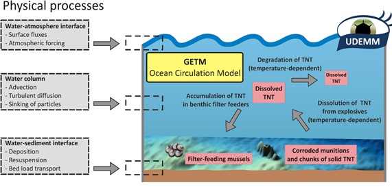
Schematic sketch of the concept of the coupled TNT-GETM model.
In a sensitivity study, the size of the open TNT-surfaces is varied between a factor 10 to 100 smaller and a factor 10 to 100 bigger than the estimated open TNT-surface of 50x50cm. The sensitivity study has been compared to measured field TNT-concentrations with the result that open TNT surfaces of 1x1cm per piece of munition are most realistic (Figure 23). The modeled TNT-concentrations show a seasonal cycle with values between 10 and 30 ng/l in summer (water temperatures between 5°C and 20°C) and about 1ng/l in winter (water temperatures below 5°C) which covers the measurements of 20-25\mug/l close to the open surfaces and less than 1ng/l in larger distances.
With the assumed filter capacity of 1.5 m3 m-2 day-1 and open surfaces of 1x1cm, mussels could accumulate 29 mg m-2 day-1 in winter and 151 mg m-2 day-1 in summer. With the assumption of 100 mussels per m2 a single mussel ends up with 29-151 ng/day. In AP4, toxicological threshold values will be estimated based on field experiments.
Near the dumping sites, mean concentrations can reach values of 30-50 ng/l. However, some ten kilometers away, the concentration drops below 5 ng/l. The model results indicate that even in the Arkona Basin dissolved TNT can be found (<1 ng/l). If one is focusing on maximum values, these occur likely in summer. The high water temperatures in combination with a thermocline and calm conditions can enhance the near bottom concentrations (like during the exceptional warm summer in 2018). The maximum values are shown in Figure 24. TNT-concentration can be as high as 100 ng/l and even locally exceed this value.
In AP1 the amount of dumped munition and the size of their open TNT surfaces is estimated based on hydroacoustic measurements and underwater video recordings the size of the open surfaces at Kolberger Heide. About 100 corroded pieces of munition was found on an area of 1260 ha with about an open TNT-surface of 50x50cm. This estimate has been applied to all dumping sides in the western Baltic Sea with the assumption that munition contaminated areas have only 10% of the open surfaces of the dumping sides and munition suspicious areas only 1% of the open surfaces.

Distribution of TNT in the near bottom layer during the MineMoni Cruise
The presented TNT-GETM model gives a first approximation of the distribution of TNT in the Western Baltic Sea region. However, several aspects could influence the results and the performance of the model as an early-warning system:
- The applied TNT parameterization is based on a limited number of observations and experiments that is extrapolated to all munitions dumping sides, munitions contaminated areas and munitions suspicious areas with a scaling factor. On the one hand, the amount of dumped munitions in the other areas as well as the open surfaces could differ. On the other hand, the composition of the hazardous substances in the dumped munition in the other areas could be different. Especially munitions produced at the end of WW2 were filled with a mix of different substances, beside TNT. This was caused by the lack of supply. TNT is one of the common compounds but there are others, not detailed investigated in this project. For instance, the seawater chemistry of RDX or HDX might be different from TNT.
- The assumed scaling factor could be over- or underestimated. The lab measurements do not take into account the biofilm covering of the open surfaces, which likely show a annual cycle. How this biofilm affects the solubility of TNT is still unknown. Moreover, until now, the effects of wind waves and currents on the solution of TNT are unknown. One can assume that an increased bottom stress, either due to wind waves or due to oceanic currents, will likely increase the solution of TNT for open surfaces. Moreover, it is likely, that under the action of surface wind waves, the vertical mixing from the bottom boundary layer to the surface is increased. Especially in the Lübecker Bucht, but also in the entire Baltic Sea hypoxia poses a challenge to higher trophic levels. Along with low hypoxic or even anoxic conditions, the occurrence hydrogensulphide (H2S) is likely. Until now it is still unclear how H2S interacts with munitions shells (increase or decrease of corrosion) or even TNT (faster/slower degradation). Anyhow, to support this hypothesis, dedicated lab experiments are needed to quantify the impact of varying bottom stress on the release rate of TNT
- Currently no information is available on the interaction of TNT and biogeochemistry. For instance Chlorophyll-a might increase or decrease the dilution of TNT. At present, we use only temperature to compute the degradation of TNT in the water column. Here, temperature is a good proxy for biological activity, but also microbiological effects. However, these effects need to be separated to account for individually.
- The present implementation of the TNT chemistry only handles TNT. As shown by the Bio-monitoring, the metabolites of TNT: 2-ADNT or 4-ADNT, pose a similar thread to the environment like TNT. Thus, the implemented simple TNT-chemistry needs to be expanded.
- Furthermore, more data of the number, type and open TNT-surfaces of the dumped munition in the different areas (dumping side, munition contaminated and munition suspicious areas) are needed to tune the model more realistic.
- Finally, the spatial resolution of GETM is 600m while Kolberger Heide is about 1200ha, which results in about 3 TNT-sources per GETM-gridbox modelled as point source. A more realistic view would be the modeling as Gaussian shaped TNT-source with declining concentration with distance and a higher spatial model resolution.
- The impact on the filter feeder mussels also depends on some estimates . More data about their distribution as well as of the mechanism how they accumulate TNT is needed.
To conclude, the coupled TNT-GETM allows for a first overview of the possible consequences of sea dumped TNT-munition in the western Baltic Sea and can built the basis for further research.
Bruggeman, J. & Bolding, K. A general framework for aquatic biogeochemical models. Environ. Model. Softw. 61, 249–265 (2014).
Gräwe, U., R. Friedland and H. Burchard (2013). The future of the western Baltic Sea: two possible scenarios. Ocean dyn. 63: 901-921, doi:10.1007/s10236-013-0634-0
Gräwe, U, Wolff, J-O, Ribbe, J, Impact of Climate Variability on an East Australian Bay Estuarine, Coastal and Shelf Science, Vol. 86(2), 247-257, doi:10.1016/j.ecss.2009.11.020
Gräwe, U., Holtermann, P., Klingbeil, K. & Burchard, H. Advantages of vertically adaptive coordinates in numerical models of stratified shelf seas. Ocean Model. 92, 56–68 (2015).
Hofmeister, R., Burchard, H. & Beckers, J.-M. Non-uniform adaptive vertical grids for 3D numerical ocean models. Ocean Model. 33, 70–86 (2010).
Klingbeil and Burchard Implementation of a direct nonhydrostatic pressure gradient discretisation into a layered ocean model. Ocean Model. 65, 64-77 (2013).
Klingbeil, K., Lemarié, F., Debreu, L. & Burchard, H. The numerics of hydrostatic structured-grid coastal ocean models: State of the art and future perspectives. Ocean Model. 125, 80–105 (2018).
Purkiani, K., J. Becherer, G. Flöser, U. Gräwe, V. Mohrholz, H. M. Schuttelaars and H. Burchard (2015). Numerical analysis of stratification and destratification processes in a tidally energetic inlet with an ebb tidal delta. J. Geophys. Res. Oceans 120: 225-243, doi: 10.1002/2014JC010325